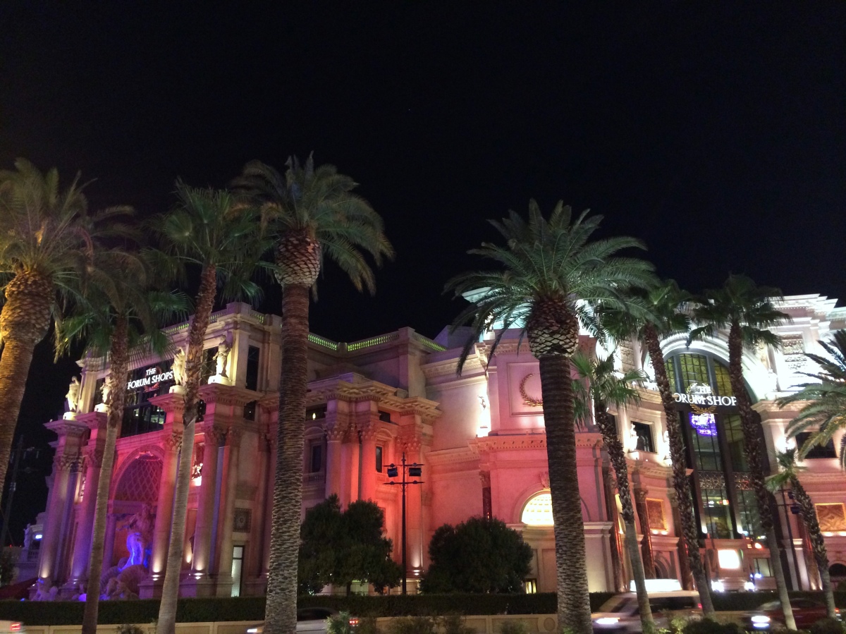
In all these days on the road trip we passed through many small and simple towns. Las Vegas, on the contrary, is a lavish city. Each hotel, in addition to being a casino, which is the main business here, is like a little town with its swanky restaurants, shops, multiple swimming pools, and fancy limousines – everything in Las Vegas is big and overwhelming.The luxurious lobbies of the hotels are breathtaking. We visited a few of the well-known hotels such as Caesars Palace and the Venetian and spent some time watching the musical fountain of Hotel Bellagio.
Hotel Paris
Entrance to Hotel Harrah’s
Interior of Caesars Palace
Interior of the Venetian
Casino
Las Vegas is teeming with tourists not just on the weekends or holidays but in fact every single day of the year and for 24 hours. Many people come here just to get married, some to spend time in their golden years, some for celebrating birthdays and some for honeymoon. There are special celebration on Christmas and Halloween.
It was time to say goodbye to our campervan Juicy who accompanied us on this trip without giving us any problems. This was the end of our journey. Home was calling us. We were going to fly back the next day.
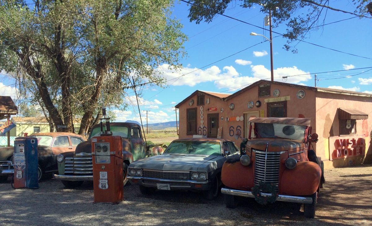
On our way back to Las Vegas we were supposed to take highway 40 but we decided to take the historic route 66 instead. This road is known by many names – Will Rogers Highway, the Main Street of America, and the Mother Road. It was built in 1926. It starts in Chicago and goes through Illinois, Missouri, Kansas, Oklahoma, Texas, New Mexico, Arizona, Nevada, and finally ends at Santa Monica in California. It is 3,945 km long. Until 1985 this road existed independent of other roads. However, later, parts of it were assimilated into other highways. About 600 km of this road passes through Arizona. It goes mostly parallel to the new multi-lane interstate highway 40.
Delgadillo’s Snow Cap Drive-In
We got onto route 66 at Williams and went up to the town of Seligman. There is a historic restaurant in this town called the Snow Cap started by Delgadillo in 1953. It is still serving food amongst a display of old cars, pickup trucks, and artifacts from the era when this road was still in use. It is a popular tourist stop. We had lunch there. The owners of this place are known to pull pranks on the visitors. So beware. There are also a few Native American areas along this road.
Pixar’s director John Lasseter was once driving on this road with his family. Based on the inspiration and idea that he had during that trip he made the 2006 animated movie ‘Cars’. They consulted road historian Michael Wallis for this movie. The town in this movie, Radiator Springs, is based on several actual small towns on this road that the team visited while researching for the movie with Wallis. This movie revived tourism on this road. Part of this movie is also filmed in the Monument Valley.
Compared to freeways in America, route 66 is much smaller. It is a two-lane road, one in either direction. Since this part of route 66 runs parallel to the freeway 40 which is not too far and is much faster, there is not much traffic on 66, which is why it is still in a good state. One has to take this road in order to approach the west entrance of the Grand Canyon National Park. We got off route 66 at Kingman and then continued to Las Vegas. We were booked in hotel Paris for two nights.
While coming back to Flagstaff that day we stopped at the famous Cathedral Rock Point in Sedona to watch the sunset. The rock glowed in red and orange hues in the rays of setting sun and looked very beautiful along with its reflection in the river. We had to spend another night in Flagstaff because being a weekend no hotels were available in Sedona. However, we did spend our third night in Sedona.
Sedona in Arizona is a town that has been developed, specifically, for tourism. It is in an exceptionally beautiful location. Similar to Mahabaleshwar (in India) was developed to enjoy the serene mountains and the view of the canyons and cliffs, Sedona is situated in a lush green valley where you can take in the beauty of surrounding mountains and interesting rock formations. It woos tourists with its calm and unhurried pace of life.
Similar to the Monument Valley, Sedona is also popular for its red rock mesas and buttes. The popular ones are Capitol butte, Courthouse butte, Coffee Pot rock, Bell rock, Castle rock, Cathedral rock and Chimney rock. The Airport Mesa is similar to the Taljai Tekadi in Pune except is larger. There is a small airport on top of it. Helicopter tours for Sedona and Grand Canyon leave from this airport.
View from downtown
Bell Tower
The town is designed to blend into its surroundings. There are no tall buildings blocking any views of the rocks. There are strict restrictions on construction locations and styles of houses, restaurants and shops. They have to blend in. The Oak Creek Canyon in Sedona used to be a well-known orchard of peach and apple trees.
The first post office opened in Sedona in 1902. The population at that time was 55. It was around 1950 when Sedona started to be recognized as a place to own a second home for vacation and a place for retirement. In 1956 the 250 ft high Chapel of the Holy Cross was built on the red rock cliff which itself is a 1000 ft high. It can be seen from a very long distance. One has to climb up to it. Although there is access provided for the disabled and elderly. There wasn’t even electricity in parts of Sedona until 1960.
Chapel of the Holy Cross
Inside the Chapel
View from the Chapel
In Sedona, there is a very beautiful arts and crafts village called Tlaquepaque on the shores of the Oak Creek. It is designed in a Mexican style. Small walking paths connect the art galleries and shops. You will find everything here from paintings, ceramic pottery, bronze and stone sculptures, glass sculptures, photography, jewelry and garment boutiques. There are many restaurants, fountains and benches to relax when you get tired. There are flowers everywhere. There is also a small church with stained glass windows. This is a popular spot for wedding ceremonies.
We spent almost an entire day here without even realizing it. To watch the sunset we went to a restaurant on the Airport mesa where people enjoy a glass of wine and good food while taking in view of the red mesa cliffs glowing in sunset.
Airport Mesa
Sedona calls itself ‘The Little Hollywood’. It is used in movies. In 1958 ‘Sedona Arts Center’ was created. Since 1995 it has been hosting an annual film festival and workshops in filmmaking. There are several music concerts for Bluegrass, Jazz, and Rock. Other than these it regularly hosts charity shows and fundraising programs. People who can afford to live here in their retirement years must feel lucky.
The next day was our day of return journey to Las Vegas. Last twelve days had gone really fast. My body was tired but my mind was yearning for more. It is interesting that when we travel to foreign places, towns and countries and take in the diversity found in nature, culture, people, geographic features, living styles and food – it feels nice for a few days but then we inevitably start missing our home. We start thinking about pithla-bhakri and kande-pohe. As Savarkar has said – the mansions here are palatial; but my mother’s hut is what tugs at my heart-strings!
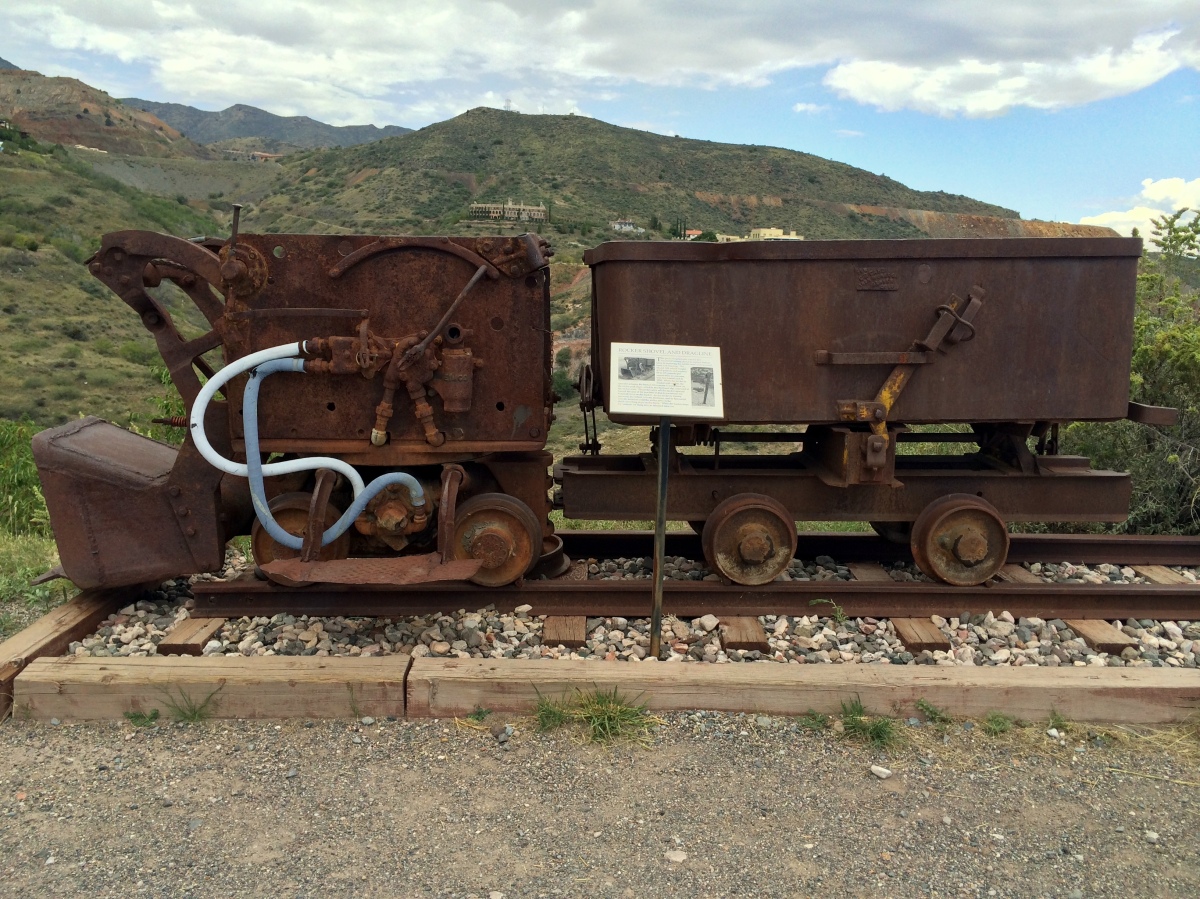
Early morning we started from Flagstaff and headed towards the village of Jerome. This place is situated on a hill called Cleopatra in the Black Hills region of Arizona. Even though Native Americans inhabited this area for centuries, the more interesting history of this region starts around 1876 when rich copper deposits were discovered in this region. United Verde Copper Company started its first mine here in 1883. The campsite of this mine was named after the main stakeholder in the company called Eugene Jerome. In addition to copper, they also found gold and silver in the Verde Valley. Until 1900, this was the most productive mine in America. A railway line was built for hauling the metals. In 1912, Little Daisy Mine Company, owned by Jimmy Douglas, started operating here.
The two companies extracted millions of dollars worth of metals. During the peak period in 1929 copper was 24 cents per pound, however, after the First World War and during the economic depression of 1932 it slid down to 5 cents per pound. By 1935, the mines were closed. Between 1924 and 1930, many villages were buried under the debris of multiple earthquakes. At its peak in 1920, the population of the town was 10,000. In 1950 population of the village was only100.
Minerals displayed in ultraviolet light
In 1953, it was decided to develop tourism in this area. In 1962, the Douglas family donated the mining sites, buildings and machinery to the government. It is now a State Park and a museum of mining history displaying photos of the bygone era, machinery, metals, minerals, ores and a model of the town and the mines. Jimmy Douglas’s library is also preserved. One can watch a film depicting history of what happened here. Jerome was declared a National Historic Landmark in 1967.
Jerome
Jerome
Jerome is now an art colony where more than 400 artists like painters, singers, instrumental players, potters and craftsmen are living. It is also a place for historic tours and biking conventions. It has become a popular tourist place with many art galleries, coffee shops and restaurants.
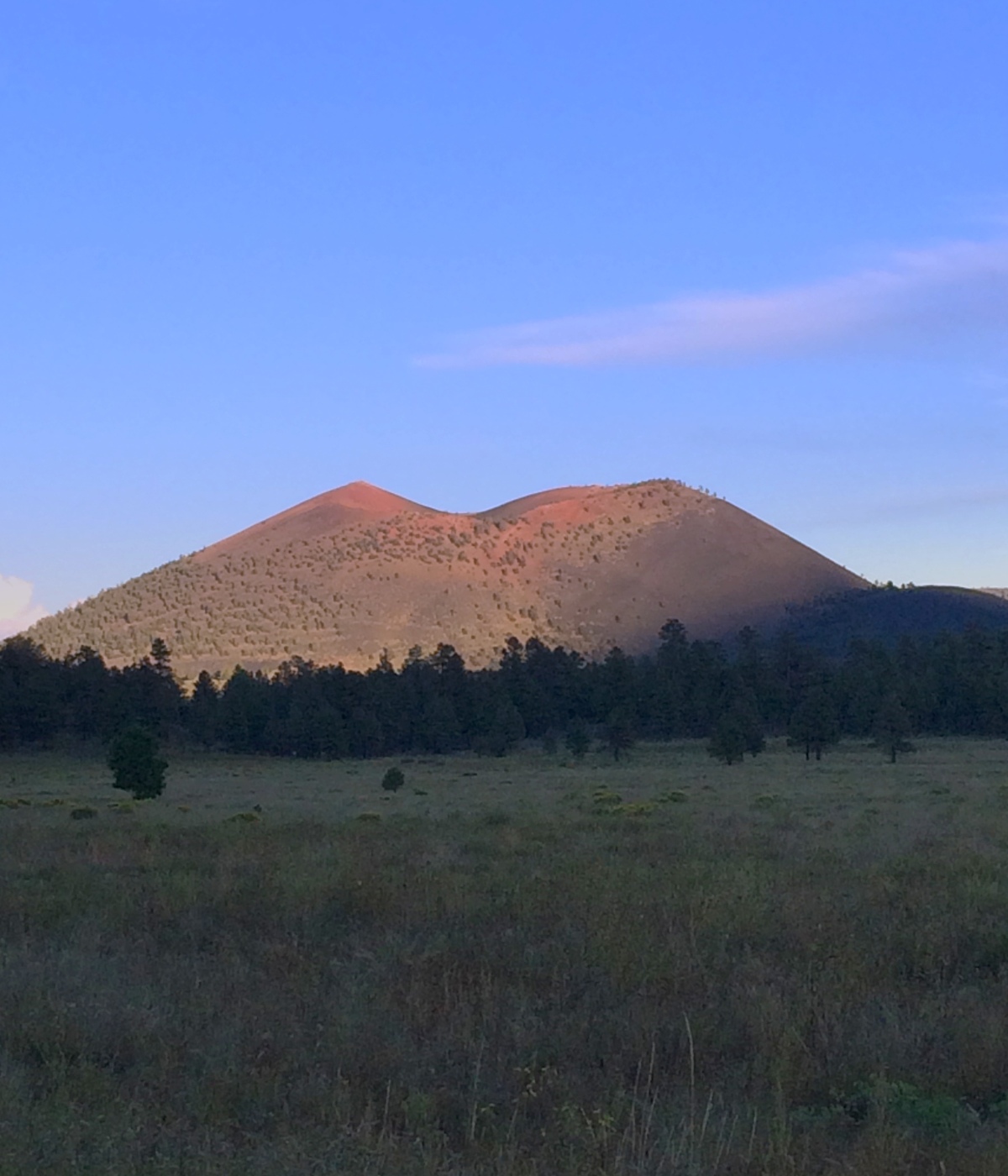
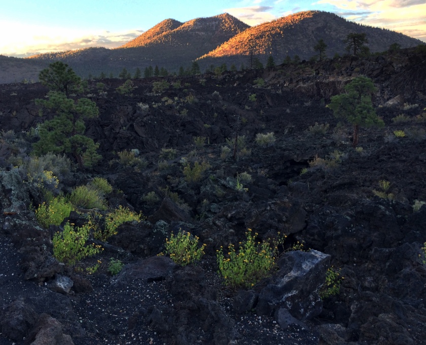
On our way towards Flagstaff, a town in Arizona where we were going to spend the night, we saw road signs for the Sunset Crater National Monument and decided to take a break there. This cone shaped crater, created by a volcano, is the most recent in the history of the San Francisco Mountain in Arizona. The cone is 1120 ft high and was most likely created in 1085.
The lava from this volcano spread mainly in the northwest direction. There is a 2 km long road that takes you up to the lava field. The rest of the area is restricted to visitors. After watching the sunset here, we headed to Flagstaff. Our actual plan was to go to Sedona, however, we could not get a hotel there due to the weekend crowd and hence, we spent the night in Flagstaff.
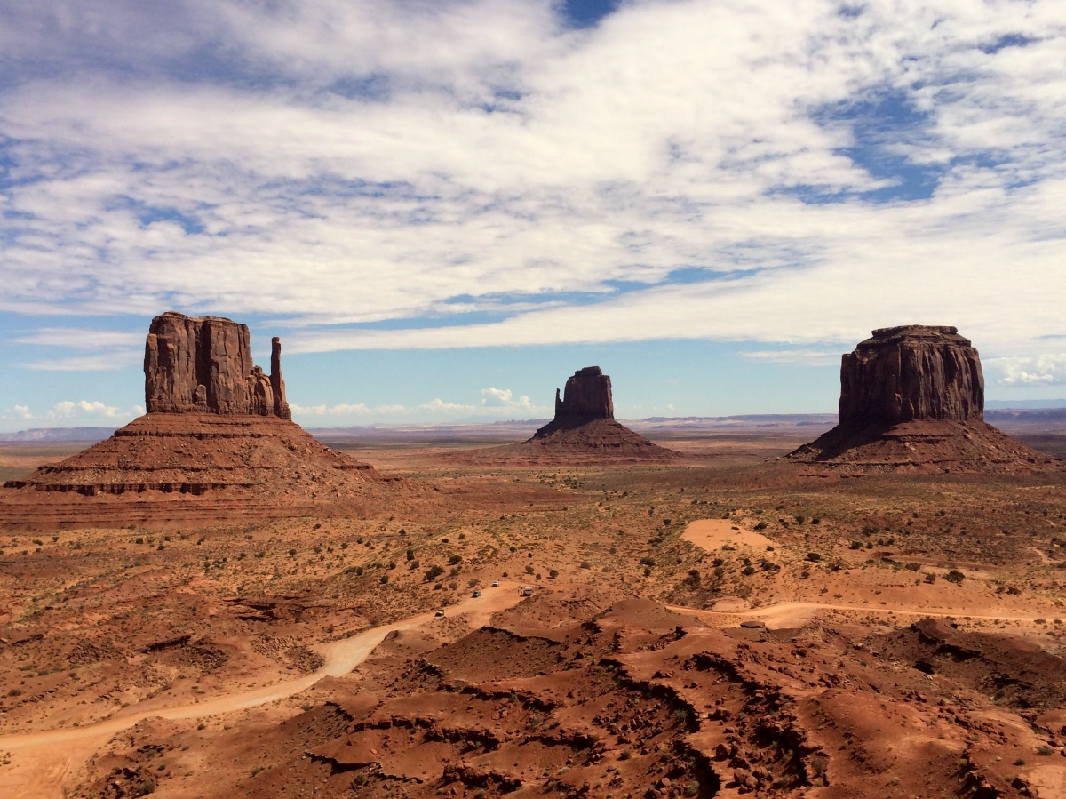
This area, popularly known as the Monument Valley, is actually a Navajo Tribal Park. It is on the border of Utah and Arizona. It is part of the Navajo Nation – a semi-autonomous Native American territory spanning over parts of Utah, Arizona, and New Mexico. This is the largest Native American Reservation. This semi-autonomous nation was created in 1868 after much negotiation with the American government. It has its own government, constitution, judiciary system, president, and police force. There are many such Native American reservations in these states. It spans around 30,000 square miles.
Nature has created these sculptures in this land inhabited by the Navajo people. Similar to Bryce Canyon, we find towers shaped by forces of nature. Unlike in Bryce, however, these are formed on flat land rather than in the canyon. They range from 400 to 1000 ft in height. There are several types of sculptures. Mesas are a boulder that appears like a “Table” land. It is the first stage of erosion. The most popular are the Rain God and Sentinel mesas. The next stage of erosion is the formation of a Butte. The popular buttes are the Elephant, the Camel and the Castle. These names are given according to their shapes. The third stage of erosion is when the Butte forming Spires. They look like poles. The popular spires are the Totem Pole and the Three Sisters.
From the road
Morning view from our campground
The Anasazi people had built their stone houses with support of mesas. These are still preserved in some places. The Navajo people who came later built free-standing earthen houses. These are called Hogans. Replicas of these are on the view near the visitor center. There are two types of Hogans. The triangular ones are called male Hogans and the round are called female Hogans. The male Hogans are for temporary use whereas the female Hogans are for permanent stay. The Navajo people now live in modern homes, however, Hogans are still used for special ceremonies.
Female Hogan
Male Hogan
There is a 27 km long unpaved road through the Monument Valley for visiting various viewpoints. You can either take your own car or travel with the guided Navajo tours in the open jeeps. While driving down to the Monument Valley, we missed some part of it due to nightfall. So we decided to retrace our way 40 to 50 kilometers inside. On this road you can see many sculptures such as the Eagle rock, King and his Throne, Sitting Hen, Sleeping Bear, Castle Butte, and Stage Coach.
John Ford Museum
Monument Valley was made popular by the Hollywood movies. Movie-making in this valley started in 1930. Near the visitor center there is a museum of the famous director John Ford. Actor John Wayne starred in a movie called Stagecoach that was released in 1939. After that another John Wayne movie – The Searchers – was shot here followed by Clint Eastwood’s The Eiger Sanction. The valley has been continuously used to this day in movies such as National Lampoon’s Vacation (1983), Back to the Future – part 3 (1990), Thelma and Louise (1991), Pontiac Moon (1994), Mission Impossible 2 (2000), and Vertical Limit (2000). Not only that but the opening song of a Telugu film called Takkari Donga was filmed here in 2002. The most recent movie that was shot here is The Lone Ranger.
This is the first national monument in the state of Utah and was designated on 16 April 1908 by President Roosevelt. It has three natural bridges. In those days there was no road to get to this park. It took three days to get here on a horse from the town of Blanding. In 1976, highway 95 was built and more people started visiting this place. In 2007 solar panels were installed in this park for electricity.
For millions of years the Colorado plateau has been undergoing erosion due to heat, cold, rain, and wind. Many times the Colorado River has changed its route. The current river route was probably made 6 lakh years ago. In 1886, a man called Cass Hite was wondering through this area looking for gold when he discovered the three bridges. The National Geographic magazine published about them in 1904 and in1908 it became a National Monument.
Over the years many names were given to these three bridges. According to their heights they were called President, Senator, and Congressman or Augusta, Caroline, and Edwin. During redevelopment of this national monument they were formally given names used by the Native American Hopi people who once lived here – Owachomo, Cachina, and Sipapu.
Sipapu
Owachomo
Kachina
The oldest is the Owachomo. It means Rock Mound. Even though the river does not flow under it now – wind, rain, and extreme temperatures are still eroding it. It is cracked in places and no one can tell how long it will last. The second eldest is the Sipapu, which means The Place of Emergence. Hopi people believe that it is the gateway through which soul may pass to the spirit world. This is the largest of the three bridges at 270 ft long and 220 ft high. The newest of the three is Kachina, which means Dancer Doll. The river still flows underneath it so it is still being formed. Since, it is not as eroded as the other two it looks enormous.
Formation of Natural Bridges (image from NPS website)
As such there is barely any difference between a natural arch and a natural bridge except the way the two have undergone erosion. A river meandering through mountains carves a natural bridge. The river eventually ends up flowing under the bridge. Arches on the other hand are created by erosion due to rain, wind, and extreme temperatures. Arches are formed upper regions of a plateau whereas bridges are formed in the lower regions. One can drive down to see the bridges. For a closer look, one needs to walk down 3 to 4 km per bridge. There is an option to take the trekking trail that joins the three bridges.
It was a rare treat when we ran into the guy from Google. He was there with his high tech equipment to capture the trails for Google Maps. Hardly did we know at this time that there was another rare treat waiting for us at this ancient place.
This area was designated as the first ever International Dark Sky Park in the world by the International Dark Sky Association. A bi-weekly stargazing event is held at its visitor center. People actually plan a night out with children at the campground for stargazing. We were very lucky that this event was going to happen that night. However there are no hotels or restaurants near this monument. Our initial plan was to leave the Natural Bridges and head to the Monument Valley before dark because we were concerned about the famous Moki Dugway, an unpaved section of Utah 261 consisting of steep switchbacks. We also had a casita booked at the Monument Valley campground and needed to reach there before the office closed. The young ranger girl at the visitor center assured us that the unpaved road was in good condition and drivable in the night. So we decided to stay back and take advantage of this golden opportunity and then drive to Monument Valley in the night. How could we miss a star party at the first international dark sky park in the world?
Those who had just come to see the bridges left before it got dark. Ours was the only car left in the parking lot of the visitor center. We took the folding chairs out and watched the sunset, took pictures. We then had dinner and waited for nightfall. The sky was very clear. We had an idea of the twinkling drama in the heavens awaited us with our experience three days back at Goblin Valley. We eagerly waited for the celestial show to begin. We were wondering if anyone else was going show up for this event. The rangers at the visitor center had started the preparation. They had brought a large telescope out on the sidewalk along with other equipment. At around 8 pm cars started coming in slowly. Very soon there were more than 30 participants including many children. They had brought chairs and even dogs. The sky slowly filled up with stars. The ranger first showed us the moons of Jupiter and the rings of Saturn. Then he showed us a globular cluster, a double cluster, Andromeda galaxy and the Veil nebula. He simultaneously clarified doubts and answered questions, and he gave a lot of information while answering questions. We enjoyed the experience immensely!
It was the most wonderful experience but we had to leave because we had a long drive ahead of us through the night part of which was on a steep unpaved road through a mountain pass. We left at 9.30 pm. There was no one on this road except us. Even though the sky was full of stars there was no moon. It was probably not a good idea to drive that night, however, we could not let go of the opportunity to attend the star party. There were only two or three tiny villages on the way. Late in the night we reached the Monument Valley. We had booked a cabin in one of the campgrounds. Had we reached any later the office would have closed and we would have had to spend the night in the car. However, we were lucky to get there in time.
Next day we went to the Arches national park. It is just outside of Moab, about 6 km to the north along a winding path near the Colorado River.
Many millions of years ago, a thousands of feet high salt bed was deposited at the bottom of an ocean that flowed in this place. The ocean evaporated leaving behind the salt bed. Later this place became a desert during which time the Navajo sandstone was deposited on top of the salt bed and eventually the Entrada sandstone on the top. Upheaval in the ground pushed up the layered rock and then rain, ice and extreme temperatures caused erosion of the softer lower layers and resulted in the forming of arches, spires, fins and balanced rocks.
Window Arch
Fins
Balanced Rock
Three Gossips
How arches are formed
There are over 2000 arches in this park. The smallest is 3 ft and the largest is 306 ft. The largest arch in the park is the Landscape Arch. As time goes by some of the older arches erode and fall while new ones keep forming elsewhere. 43 arches have collapsed since 1977. It is not allowed to climb on any arch in this park. This park was designated as national park on 12 November 1971.
The Rise and Fall of an Arch
Where there was an arch before
You can visit the prominent arches in this park by car using the Arches Scenic Drive. It is 30 km long. We stopped at the Shiprock, the Courthouse, the Petrified Dunes viewpoints, and the Balanced Rock. This looks like a large rock placed on the narrow top of tall rock. It was formed from a single large rock when the softer middle portion was eroded away. In the course of time the large rock on the top will fall off. Nearby there is a butte called the Elephant Butte because this rock formation looks like a herd of elephants. Since there are no elephants native to the American continents, the people here are very much attracted to them. We came across such Elephant Buttes in other parks also.
Towards the east end of the road there is a section of many arches called the Windows Section. Apparently, some scenes in the movie Indiana Jones and the Last Crusade were shot in this section of the park. One has to walk 1.5 km to get there. At the end of the trail there are three arches – the Turret Arch and in front of it there are two arches side by side called the North and the South window arches. Slightly to left of the Windows Arches, there is a Double Arch that is formed by two arches connected at one end, like Siamese twins.
Every arch in this section is nature’s architectural wonder. Later we visited the Panorama point and then the Devils Garden. There are three arches here – the Broken Arch, Sand Dunes Arch, and Skyline Arch. Broken arch fell recently due to forces of nature. Information about the arch demolished by nature is given on the display board on site showing a picture of the original arch and describing the process of formation and destruction of arches.
After that we visited the Tunnel Arch and then the Pine Tree Arch. There is a pine tree growing right at the center of this arch that looks really beautiful. Perfect for a photo! The largest arch in the park is the Landscape arch and is 2.5 km away from the parking lot.
Pine Tree Arch
Tunnel Arch
Double Arch
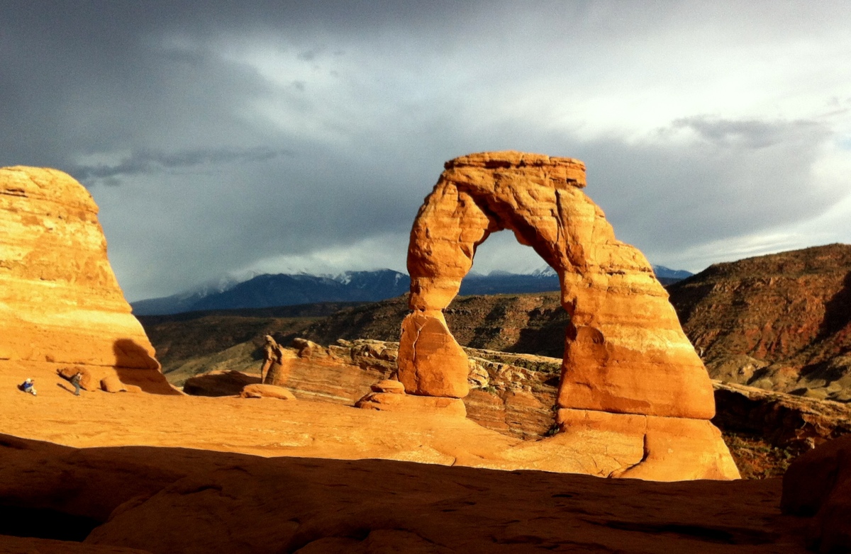
For sunset we were headed to the most popular arch in this park, the Delicate Arch. This arch is also far from the parking lot and is located at a height of about 5000 feet and requires a walk of about two kilometers uphill to see. I was tired after a whole day of walking in the blazing sun. It seemed impossible to climb up all the way before sundown, so we skipped this hike and chose to view it from a lower point that is easily reachable. This viewpoint is specially created for disabled and elderly people who will not be able to walk up to this arch. That is so thoughtful! While in Pune, there are no easy sidewalks or preferential treatment for the elderly.
In the evening we took a stroll on the main street in Moab and visited some art galleries and then had nice Chinese food for dinner. In the morning we got up early to head to the Monument Valley with a stop at the Natural Bridges National Monument on the way. This monument has the second largest natural bridge in the world. The largest natural bridge is also in Utah in the Glen Canyon called the Rainbow Bridge.
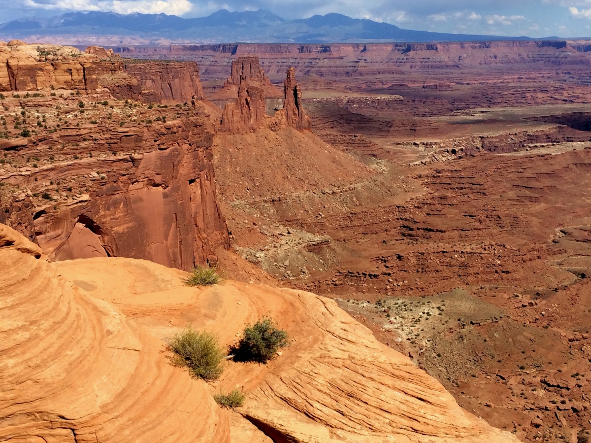
From the Dead Horse Point we went to the Canyonlands National Park using the road that takes you over to a mesa called the Island In the Sky. The confluence of the Colorado and the Green river both flowing southwards has split the land here in three districts – Island in the Sky, Maze District and Needles District to. The plateau at a height is Island of the sky; to its South-East that has red and white pillars is the grasslands, the Needles; and the plateau stretching from South-West is the Maze.
Canyonlands is made of many colorful canyons, mesas, and buttes that present a symphony of colors, delighting the passersby. John Powell discovered it in 1869 while he was on his historic trip through the Colorado River. President Lyndon B. Johnson declared it as a national park on 12 September 1964. More than 400,000 people visit this park each year.
This park is spread over a very large area so we decided to visit a few chosen locations. In any park one has to walk at least a little bit to get to the viewpoints. Sometimes these are easy or moderate walks but sometimes they can be very strenuous. The park information booklet gives clear information about the difficult level of each trail as well as the distances. It was not possible for me to do the strenuous trails so we picked a few easily accessible but popular viewpoints.
Canyonlands View
Upheaval Dome
We did the Whale Rock trail, which is 2 km walk, the Grand Viewpoint (again 2 km), the first look of the Upheaval Dome (1 km) and finally, the Mesa Arch (half a kilometer). The Upheaval Dome is not a dome above the ground but rather, it is a dome shaped yawning hole in the ground about 1000 feet deep. This crater could have been caused by a meteor fall. On our way to the Grand Viewpoint we stopped at the Buck Canyon overlook. Mesa Arch is a natural arch created in a rock raised due to upheaval and then the softer lower layers being eroded by wind, rain and heat. The top of this arch is a bit flat so people were climbing over it to take pictures. The view from inside the arch is very beautiful. From here you can see canyons, buttes in the valley and La Sal Mountain in the distance. In the end we went to the Green River overlook to view the sunset. It was beautiful as always.
May it be a river or a mountain, a plateau or an ocean, sunrise and sunset are always beautiful and introspective. Out of the three regions we spent time only at the Island in the Sky. The other two regions are far and have to be accessed using separate roads. The Island in the Sky gets the largest number of visitors. This park is also popular for trekking, river rafting, rock climbing, horse-riding, and camping. There are regularly scheduled ranger talks on fauna and flora – it’s history and geology.
After this park we went to our hotel in the town of Moab. This is a small but beautiful town. On our evening walk through the town we stumbled upon a nice Italian restaurant and had pasta for dinner. It felt good to eat at a nice restaurant after several days of camping food.